3D Laser Scanning & More
Powerful Scanners - Scalable Solutions
With scanning technology we can help you easily capture existing condition data for accurate adaptive reuse and renovation construction planning and design.
3D Laser Scanning Solutions from BuildingPoint Central
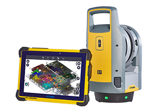 The Trimble X7 is simple, smart, and professional. A high-speed 3D laser scanning system allowing for scan and BIM data to be referenced, registered and refined in the field. The X7 increases productivity with fast, high quality scanning combined with Trimble Field Link construction software. The new Trimble X-Drive system enables automatic calibration to ensure accuracy on every scan with no downtime for costly and lengthy calibration service. Includes high sensitivity time-of-flight EDM to effectively capture dark and reflective surfaces and fast image capture for full panoramas and scan colorization with Trimble® VISION™ technology. Also, an integrated laser pointer to support in-field deliverables and workflows. All complete with Trimble Field Link Scan Module; construction specific software to easily operate the Trimble X7 and reference scan projects with design documents.
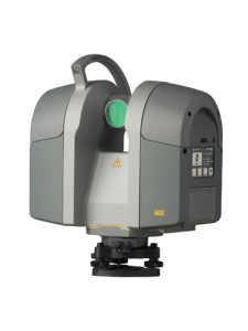
The Trimble TX8 Laser Scanner produces the high quality results needed for comprehensive worksite data collection. The TX8 lets contractors gather data more quickly from each setup while the long-range capacity reduces the number of setups needed to get the job done. Complete with Trimble’s patented Lightning™ technology, the TX8 can measure one million points per second while capturing precise data over its full measurement range of 360 degrees and 317 degrees. The TX8 has an eye-safe Class 1 non-visible laser making this safe to use even in busy public places. Also, a color touchscreen display and one-button scanning make data capture easy and efficient.
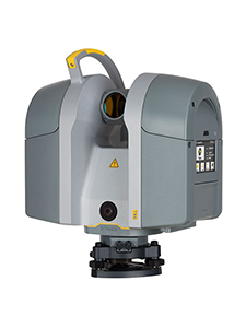
The Trimble TX6 3D Laser Scanner is a cost-effective 3D scanning solution based on the same advanced time-of-flight technology as the Trimble TX8. The Trimble TX6 high scan speed and accuracy make it the most productive scanner in its class and it’s built for demanding environments. Data from the Trimble TX6 loads directly into Trimble RealWorks and Trimble Scan Explorer software for automatic scan colorization and registration. Produce powerful deliverables or export data to CAD software.
Trimble Realworks
 Visualize and Extract Compelling Deliverables from 3D Data. Trimble 3D scanning software allows you to integrate 3D point and survey data to extract measurements, generate deliverables, and utilize inside 3D CAD software. Trimble RealWorks is specifically designed for point cloud processing and analysis. The software provides a complete solution to efficiently register, analyze, model, and create deliverables using data from virtually any source.
Trimble RealWorks has integrated floor flatness analysis, point cloud modeling tools, as well as full 3D point cloud to model inspection for clash detection. This industry first tool allows contractors to ensure things were installed accurately and takes away all field verification.
What Is 3D Laser Scanning?
3D laser scanners use EDM (electronic distance measurement) reflections which result in millions of independent coordinate measurements each second to create an accurate and precise 3D digital record of the scanned area. These coordinate points combine to form point clouds, with each coordinate having an X, Y, and Z value to give you an exact measurement of each and every point that makes up the point cloud. These coordinate values can also be used to georeference or align the point cloud to the real-world environment.
Point clouds make up the spatial relationship of the objects in an area to give precise dimensions between and within objects like floors, walls, ductwork, and piping.
What Are 3D Laser Scanners Used For?
The most common uses for laser scanning in construction are for as-built verification in pre-construction or renovation, QA/QC, and progress reporting during construction. Trimble 3D laser scanners provide contractors with information that can help verify a construction project is free of flaws or if there may be issues that need to be addressed. 3D lasers can capture information or data for:
- Designing upgrades or expansions for buildings
- Document existing conditions
- Preserve historical builds
- Virtually construct and design a project
- Quality Assurance and quality control
- Simulations
- Construction scheduling
- Progress verification
Benefits of 3D Laser Scanning
3D laser scanning solutions come with numerous benefits:
- Quick and accurate 3D representation of existing structures
- Reveal clashes or design conflicts between systems prior to build
- Determines exact measurements and dimensions
- Provide reference data for new building design and retrofit
3D laser scanners can help save contractors time and money. Using a Trimble 3D laser scanner on a job site will provide you with exact measurements quicker than ever before. This technology will also save you money on your project by catching any conflicts or design flaws before they become rework or require an RFI. Having exact measurements and knowing of any existing issues will allow you to compensate appropriately and save money on materials.
When to Use Laser Scanning
A laser scanner is highly valuable during a renovation project or throughout the phases of a new build. Using 3d scanning can aid the building information modeling (BIM) aspect of your build through careful documentation of the site’s progression. This thorough documentation will allow you to go back to the source of any error you find and deal with it as needed.
Scanning a renovation project will provide a detailed 3D point cloud of the building, which can be converted to an accurate model, providing a comprehensive picture of the current integrity of the building. Documenting all renovation stages will also yield a top-level view of progress made on the project.
Importance of Compatible Software
Choosing the correct software will allow you to:
- Scale the solution to suit your needs
- Register and refine data
- Segment and classify data
- Model from point cloud
- Compare point cloud versus 3D model
- Import and export the most common data formats
- Produce report deliverables that contribute to project decisions
- Publish and share important point cloud data with stakeholders
The most important part of the laser scanning process involves working with a suitable point cloud processing software.
Point cloud processing software should be able to scale with your needs as a contractor. It is quite likely that as you become more comfortable with laser scanning, your software processing expectations will expand, and your software should be able to do the same. There is no “one size fits all” solution. Your software solution should be modular and allow you to add capability as your project requirements dictate.
Processing software should have a simple, automated process for registration and refinement of the point clouds. This is the most important step in producing accurate point clouds that can be used effectively in the construction process. The best solutions call for very little human interaction and apply complex algorithms that can automatically detect surfaces and objects to precisely align large numbers of point clouds in a very short period of time.
Once the data has been registered and refined, it typically needs to be segmented into smaller, more usable sections in order to simplify the workflow. Segmentation of the data will allow the user to pare down data into digestible pieces that can be viewed and shared among stakeholders very easily. This process helps tremendously when running reports on floor flatness, deviation, or cloud to model variations.
After having registered and segmented the point cloud into smaller usable sections, most users want to generate deliverables that can be used to guide the health and quality of the project. Some examples of these deliverables are floor flatness, model to cloud deviations, pre and post pour concrete object placement validation, post-installation quality checks on piping, and ductwork.
Finally, there are many stakeholders that have an interest in point cloud data, and the processing software tools should be able to be published and shared with stakeholders in all the most common formats. This means that whether you are an owner, architect, engineer, GC, or sub-trade, you should be able to send or accept point cloud data to others on the project without the need for costly and complicated tools.
Contact Us to Learn More
Want more information about the different Trimble 3D scanners and compatible software? Request a demo today!
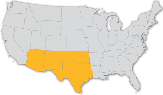
WE ARE WHERE YOU ARE
Serving AZ, NM, OK & TX